Thursday, August 21, 2014

World Map Wrapped Canvas Print (1780)

Hey everyone! Today we are going to show off our vintage world map wrapped canvas print reproduction that was originally produced in 1780. The map is a singular linear view of the world, unlike the dual globed world maps that display the 2 hemispheres of the earth. The continents and their borders are drawn with differentiating colors that give this map a vibrant and almost modern display. Locations throughout the continents are labeled as well as the longitude and latitude and the the equator. The wrapped canvas is fully customizable in that the dimensions can be changed to the users desired specifications. Click the image and link below to take a closer look at this beautiful vintage world map wrapped canvas print reproduction that was originally produced in 1780!

Wednesday, August 20, 2014

Vintage World Map Wrapped Canvas Print (1641)

Hey Everyone! Today we are going to be showing you guys our vintage world map wrapped canvas print that was originally produced in 1641. The map is a dual hemisphere map of the earth in that the eastern and western hemisphere is displayed in two circular globes. There is background artwork that displays 4 prominent people of that time period. The artwork also displays historical events that are situated around the globes as well. The wrapped canvas is fully customizable in that the dimensions of the print can be augmented and changed. Click the image and link below to take a closer look at this beautiful vintage world map wrapped canvas print reproduction that was originally produced in 1641.

Tuesday, August 19, 2014

Vintage World Map Wrapped Canvas Print (1918)

Hey everyone! Today we are going to show off our vintage world map wrapped canvas print that was originally produced in 1918. The map itself details lots of information pertinent to world war I. The map is a completely linear map of the earth in that there are no hemispheres displaying the western and eastern hemispheres. This map is printed on a wrapped canvas and can be modified dimensionally in terms of Width and Height. The thickness of the wrapped canvas can also be modified as it pertains to amount of distance it sticks out from the wall. Click the image and link below to take a closer look at this beautiful vintage world map wrapped canvas reproduction print that was originally produced in 1918.

Tuesday, August 12, 2014

Vintage World Map Poster (1799)

Hey everyone! Today we are going to be showing off our vintage world map poster reproduction that was originally produced in 1799. It is a linear world map in that it displays the world on a continuous horizontal display. The longitutdes and latitudes are displayed on the edges of the map as well as on the equator. Continents and their respective borders are also differentiated with colored lines along their borders. This poster is fully customizable in that the dimensions can be changed and a frame can be added to the print. Click the image and link below to take a closer look at this vintage world map poster reproduction that was originally produced in 1799.

Monday, August 11, 2014

Vintage World Map Poster (1775)

Hey everyone! Today we are going to be showing you guys our vintage world map poster that was originally produced in 1775. It is a dual hemisphere world map in that the eastern and western hemispheres of the earth are displayed. The longitudes and latitudes are labeled on the edges and the equator on the map. There is some beautiful trim artwork on the edges of the hemispheres with information about the publication of this map. The poster print itself is fully customizable in that the dimensions be changed, but also many different frames and be added as well. Click the image and link below to take a closer look at this beautiful world map poster reproduction!

Friday, August 8, 2014

Vintage World Map Poster (1630)

This is a vintage world map poster that was originally produced in 1630. The map is a dual hemisphere map in that we get to see the eastern and western hemispheres. This map also has an immense amount of detail and painting around these hemispheres, that depicts the historical events and the important people of that time. The map also labels the longitude and latitude lines of the equator and on the edges of the hemispheres. The poster is fully customizable in that the dimensions can be changed and an option for a frame can be added as well. Click the image and link below to take a closer look at this beautiful vintage world map poster reproduction that was originally produced in 1630!

Thursday, August 7, 2014

Vintage World Map Poster (1852)

Hey Everyone! Today we are going to show off our vintage world map poster that was originally produced in 1852. It is a linear map of the earth in that the continents are laid out and displayed in a singular rectangular box. The countries throughout the world are differentially colored in order to accurately display their respective borders. The various oceans throughout the world are also labeled and the map is displayed with a beautiful border. The poster itself can is fully customizable in that the dimensions can be changed and also that a frame can be added. Click the image and link below to take a closer look at this beautiful vintage map of the world poster reproduction that was originally produced in 1852.

Tuesday, July 29, 2014

World Telegraph Map Poster (1855)

Hey everyone! Today we are going to show off our vintage world telegraph map poster that was originally produced in 1855. Obviously you can see that it displays the various telegraph lines that traveled across the world. The majority of lines seem to travel over the Atlantic ocean in a Cingular area which connects to a network throughout Europe. The Pacific ocean seems to have a few telegraph lines, but nowhere near the same amount the Atlantic has. This vintage map of the world is in English and has labeled several important regional locations. Click the image and link below to take a closer look at this historical world telegraph map poster print reproduction that was originally produced in 1855!

Monday, July 28, 2014

Vintage World Map Poster (1870)

Hey everyone! Today we're show you guys our vintage world map poster that was originally produced in 1870. It is a linear global view map it and displays all the continents of the world as well as many different shipping routes throughout the ocean. The map also has two globes at the top of it displaying the geographical qualities of the north and south poles. The poster itself is fully customizable in that the dimensions can be manually changed. Also the poster has several different options for the addition of many different wall frames. This world map poster is perfect for the living room, the bedroom, the office, the study or anywhere you desire to contribute some beautiful historical decor. Click the images and link below to check out this vintage world map poster that was originally produced in 1870.

Sunday, July 27, 2014

Vintage World Map Poster (1744)

Hey everyone! Today we're going to show off our beautiful world map poster reproduction that was originally produced in 1744. It is a dual hemisphere map that displays both the eastern and western hemispheres. The continents of the world are also colored to enable easy identification. There is vintage artwork that is displayed in the background corners of this document. The latitudes and longitudes are also labeled on the edges of the globes and on the equator. This world map poster can be customized dimensionally and has options for several different types of frames. This vintage world map poster is perfect for the living room, bedroom, study, office or anywhere that you have historical decorative needs. Click the image and link below to take a closer look at this beautiful world map poster reproduction!

Friday, July 25, 2014

Vintage World Map Poster (1801)

Hey everyone! Got another world map poster to show you guys! This world map was originally produced in 1801 and is a completely linear map of planet earth. The continents are individually colored which assists with locating various borders. The equator and longitudes and latitudes are labeled throughout this map. Ocean voyages of the past are also labeled with their respective dates of travel upon the dotted lines. Mountains and rivers are illustrated on many different land areas. Bodies of water such as bays, oceans, lakes are also labeled throughout. This vintage world map poster is perfect for the living room, bedroom, office or anywhere you want to present a historical decoration. The poster specifically can be modified in two different ways. The dimensions of the poster can be customized and frames can be added to the poster as well. Click the image or link below to take a closer look at this beautiful world map poster reproduction that was originally produced in 1801.

Thursday, July 24, 2014

Vintage World Map Poster (1641)

Hey everyone! Today we are going to show you guys another vintage world map that is in our collection. It is a map that was originally produced in 1641 and is a dual hemisphere globed map. The two globes display the eastern and western hemispheres as well as the equator and latitudes and longitudes. The Map is written in Latin and has 4 distinct historical individual portraits at the corners of the map. This world map also has artistic depictions of nature and mythology that are displaying around the globed map. We have this world map poster available for purchase on our online store. This world map poster can be fully customized in that the dimensions can be changed and frames can be added. Click the image and link below to take a closer look at this beautiful world map poster reproduction that was originally produced in 1641.

Wednesday, July 23, 2014

Vintage World Map Poster (1680)

Hey everyone! Today we are yet again going to show off one of our beautiful world maps. It is a world map that was originally produced in 1680. It is a globed map in that it displays the western and eastern hemispheres of the world. It also displays the northern and southern hemispheres as well. Around the mapped areas are various artistic depictions that display paintings of farming, angels and mythology. The map seems to be written in a romance language, most likely Latin. The longitudes and latitudes are labeled on the equator and the edges of the globes. This map poster is fully customizable in that the dimensions of the poster can be changed. Also the poster can be modified with the addition of several different frames. Click the link below to take a closer look at our beautiful world map poster available for customization and purchase!

Tuesday, July 22, 2014

Vintage World Map Poster (1689)

Hey everyone! Today we are going to be showing off our vintage world map poster reproduction that was originally produced in 1689. The map is a two hemisphere globed map. The map also includes mini globes that illustrate the northern and southern hemispheres of the earth. Around the globes are various artwork depictions that display the history of the world in that time period. On the map hemispheres the equator as well as the longitudes and latitudes are marked throughout. The continents are also displayed with dark bold lines along their borders. This world map poster is perfect for the living room, bedroom study, lounge or anywhere you need historical decorations. This world map poster can be fully customized in that the dimensions can be adjusted and frames can be added. To take a closer look at this beautiful world map poster click the image and link below!

Monday, July 21, 2014

Vintage World Map Poster (1831)

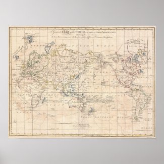
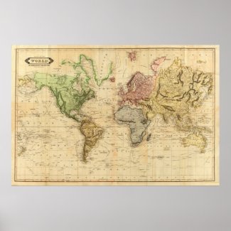
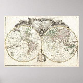
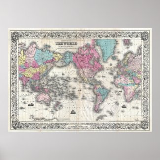
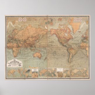
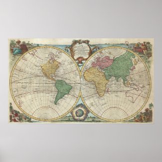
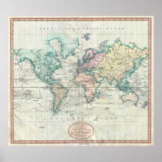
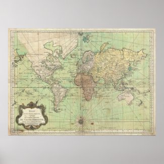
Hey everyone! Today we are going to show off yet another one of our many vintage world map posters. The world map presently at the bottom of this blog post was produced in 1831. Every continent on the world map are represented by different colors along their respective borders. The oceans are colored with a light tan backdrop. The longitudes and Latitudes on this map are labeled on the edges. The equator  as well as shipping routes are also labeled throughout this map. Many locations are labeled throughout this map that include cities, regions, ocean, rivers, mountain ranges and much more. This vintage world map poster can be fully customized by either the dimensions of the map itself and also by the framing options that are available. This map is perfect for decorating a living, a bedroom, a lounge and anywhere you want to bring about a nostalgic historical decor theme. Click the link below to take a closer look at this beautiful world map poster that was produced in 1831.
Vintage Map of The World (1831) Posters
Vintage Map of The World (1831) Posters by Alleycatshirts
Browse through more Posters, Art & Prints at Zazzle.com

Saturday, July 19, 2014

Vintage World Map Poster (1875)

Hey everyone! Today we are going to be showing off our vintage map of the world poster that was produced in 1875. The continents on the world map are colored with a light grey color while the ocean is colored with a light blue. This allows the viewer to easily distinguish the areas between land and sea as well as read the text on labeled locations. The map is written in English for which oceans, continents, countries, cities and regions are labeled. The latitudes and longitudes and equator are also labeled on this map as well. The popular shipping routes throughout the worlds oceans are also labeled with destinations as well as distances. This map is available for purchase through our online store! You can fully customize this map by changing the dimensions, changing the printing materials and also by adding and customizing beautiful frame. This map is perfect for decorative wall art in either a living room, den, study, office, bedroom, lounge and anywhere you desire a nostalgic and historical decorative flare. Click the link below to take a closer look at this beautiful world map poster reproduction.

Friday, July 18, 2014

Vintage World Map Poster (1778)

Hey everyone! This is another one of our vintage world map posters that was produced in 1778. The map is written in French and has many labeled locations. The Longitudes and Latitudes are labeled vertically and horizontally on the map. A Compass rose is located at the bottom middle of the map. The continents of this map very in color shades in order to distinguish their borders. Bodies of water such as bays, rivers, oceans and lakes are labeled throughout this map. This map poster is perfect for anyone who wants to decorate a home with a beautiful historical map of the world. This poster can be fully customized in that the customer can not only change the sizes of the poster but also add desired frames. Start decorating your home today! Click below to take a closer look at this beautiful World map poster that was produced in 1778.


Thursday, July 17, 2014

Vintage World Map Poster (1685)

Hey everyone! Today we are going to show off one of our vintage world maps that was produced in 1685. It is a globed map in that it displays 2 hemispheres of the world and has a background of artwork around the hemispheres. The map has latin text at the top of the map and has 4 different artwork paintings at the corners of the map. The map also displays the top and the base of the hemispheres, displaying the north and south poles. The map can be framed with many different options. The size of this poster can be fully customized and adjusted to the specifications of the customer. To take a closer look at this beautiful world map poster, click the image and or link below!


Wednesday, July 16, 2014

Vintage World Map Poster (1780)

Hey Everyone! Today we are going to show off another vintage world map that was produced in 1780. As you can see below the continents all have contrasting colors to enable the user to easily see a global view of the continents of the world. The text written on this map is in a Latin derived language which I believe to be Spanish. The Latitudes and Longitudes are labeled on the vertical and horizontal edges of the map. The equator and the oceans are also labeled on this map. This colorful vibrant world map is perfect for any living room, lounge, office or bedroom. Click the link below to take a look at this beautiful world map poster!

Monday, July 14, 2014

Vintage World Map Poster (1918)

Hey everyone! Today we are going to show off one of our vintage world map posters that we offer on our zazzle.com store. The poster is resizable and can be accompanied with a fully customizable frame. The world map shown was originally produced in 1918 by the Daily Telegraph. The map has many locations labeled as well as the territories claimed by different countries. The ocean voyages from destination to destination are labeled in terms of traveling distance. At the key of the map the a global view shows captured territories of the United States, the French, the Dutch and Italians. The map also as the longitudes and latitudes labeled on the vertical and horizontal edges of the map. This world map poster is perfect for any living room, office, lounge, study and much much more. Click the link below to take a closer look at this beautiful map!
Vintage Map of The World (1918) Print
Vintage Map of The World (1918) Print by Alleycatshirts
View other World Posters at Zazzle.com


Check out more maps at our Vintage Map Decor Blog at vintagemapdecor.blogspot.com